


Voting District 0053864005003, Allegan County, Michigan
About
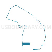
Outline

Summary
| Unique Area Identifier | 595807 |
| Name | Voting District 0053864005003 |
| County | Allegan County |
| State | Michigan |
| Area (square miles) | 1.23 |
| Land Area (square miles) | 1.23 |
| Water Area (square miles) | 0.00 |
| % of Land Area | 100.00 |
| % of Water Area | 0.00 |
| Latitude of the Internal Point | 42.75402020 |
| Longtitude of the Internal Point | -86.11895040 |
Maps


Graphs
Select a template below for downloading or customizing gragh for Voting District 0053864005003, Allegan County, Michigan


Neighbors
Neighoring Voting District (by Name) Neighboring Voting District on the Map
- Voting District 0052812000001, Allegan County, MI
- Voting District 0053864004002, Allegan County, MI
- Voting District 0053864005001, Allegan County, MI
- Voting District 0053864005002, Allegan County, MI
- Voting District 0054518000003, Allegan County, MI
Top 10 Neighboring County Subdivision (by Population) Neighboring County Subdivision on the Map
- Holland city, Allegan County, MI (7,016)
- Laketown township, Allegan County, MI (5,505)
- Fillmore township, Allegan County, MI (2,681)
Top 10 Neighboring Place (by Population) Neighboring Place on the Map
Top 10 Neighboring Unified School District (by Population) Neighboring Unified School District on the Map
Top 10 Neighboring State Legislative District Lower Chamber (by Population) Neighboring State Legislative District Lower Chamber on the Map
Top 10 Neighboring State Legislative District Upper Chamber (by Population) Neighboring State Legislative District Upper Chamber on the Map
Top 10 Neighboring 111th Congressional District (by Population) Neighboring 111th Congressional District on the Map
Top 10 Neighboring Census Tract (by Population) Neighboring Census Tract on the Map
- Census Tract 322, Allegan County, MI (5,286)
- Census Tract 324.02, Allegan County, MI (3,751)
- Census Tract 324.01, Allegan County, MI (1,520)
- Census Tract 326, Allegan County, MI (1,434)